Saturday, January 31, 2015

The Republic of Whangamomona

The Republic of Whangamomona is a small township located along Highway 43, also known as the Forgotten Highway. The town of Whangamomona was officially established in 1897, 2 years after settlers arrived in the area. In 1989 it became a Republic, in protest of a change in boundary lines for the regional councils. Until 1989, Whangamomona was in the Taranaki district, but the new boundaries would change that so the township became part of the Manawatu-Wanganui district.
The township wanted to remain part of Taranaki, and since new boundary lines did not allow this, they declared themselves a Republic. Since then, there have been 27 Republic of Whangamomona Independence Day celebrations. They are now held once every two years, and have become a festival which attracts visitors from far and wide. An important part of the celebration is electing the next president. The first president was Ian Kjestrup, and was in office for 10 years. The first elected animal president was Billy Gumboot the Goat, who won the 1999 election by eating the other candidates’ ballots.


The 2015 Independence Day celebration was held on 24 January. It was a lovely sunny summer day, the hottest so far this summer. It would be hard to say how many people attended, but the number of people in the space available made it look like a good crowd. When you reached the edge of the Republic you were greeted by border control, who presented you with a Republic of Whangamomona passport, in exchange for $5. Once you cleared the border, you were sent to immigration to get your official entry stamp on the passport.

I got there just in time to watch the Gutbuster. Each year contestants join in a race up to the top of an incredibly steep hill (which also doubles as a sheep field) and back down. I was quite impressed with how quickly some of the runners made it to the top. The oldest contestant was 67 (he apparently runs the race every time they hold it), and the youngest looked to be somewhere between 6 and 9. All I could think was kudos to them, both because of the temperature (the race was held at 1230, so not the coolest part of the day), and because of the course for the race.


While we browsed stalls selling all manner of local arts, crafts, and trinkets (and yummy things like meat pies, homemade baking and ice cream), we had the pleasure of enjoying a bagpipe band populated by local players of all ages. After a nice picnic lunch in the shade (the sun was ridiculously hot, 27 degrees Celcius), we enjoyed the next round of competitions.
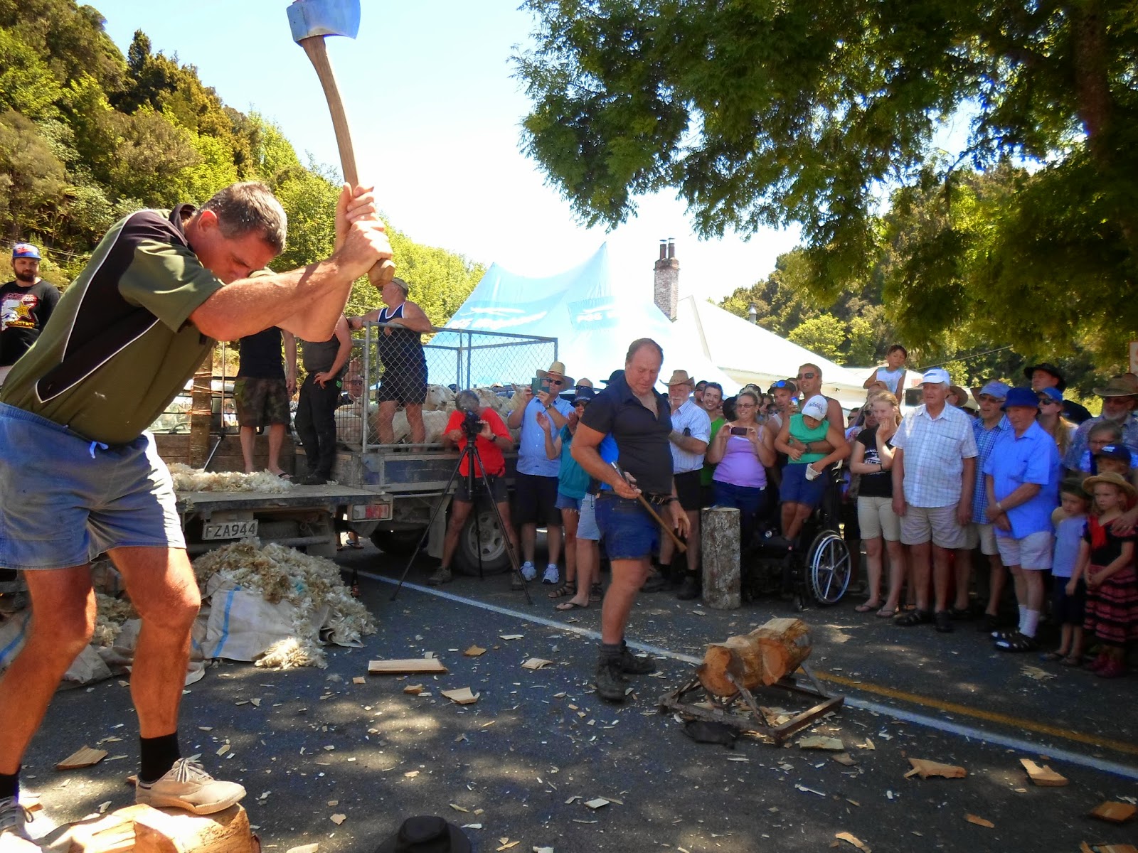

Teams of 5 people were put together for this event. One person hammered a nail into a stump, the next had to shear a sheep, up third was a wood-chopper, followed by a pie-eater and lastly a pint-drinker. The competition was open to anyone willing to take the challenge. Some of the wood-choppers were as young as 8 or 10, and eager to show off their skills.
Blade shearing

Team Sports


Shearing competition t-shirt

 The last event I saw before deciding it was time to head towards home was a demonstration of how to shear a sheep with blades instead of an electric shearer, (blade-shearing is the traditional way). I’d say it definitely takes a bit of skill to wield said shears, as the handle alone was bigger than my hand. Following the sheep shearing was a demonstration on how to skin possums. New Zealand possums look quite different from the US variety, but they are still not cute. Apparently the tail is the most valuable fur off the possum. The fur can be sold and it goes for making Possum/Merino scarves, hats, etc.


NZ possum
Although I did not stay all day, other events planned for the remainder of the day was a sheep race, electing the new president of the Republic, and gumboot throwing.

Monday, January 26, 2015

The Forgotten World Highway

The Forgotten World Highway is a 150-kilometer long road that runs from Stratford to Taumaranui, mainly in the Manawatu-Wanganui district. The only real town (or settlement) once you leave the Stratford area is the Republic of Whangamomona, which is about halfway. The Highway is a winding up and down adventure through mostly unsettled, New Zealand countryside. The road was built along Maori trading routes and pioneering farm tracks.


As you leave Stratford, you see a sign indicating the Forgotten World Highway has begun. A few feet further down the road, you see another sign, this one telling you there are no gas stations for the next 150 kilometers. It takes 2-3 hours to drive the entire Highway. This might seem like rather a long time for only 150k, but the road is far from straight. It winds over 4 mountain saddles as you make your way to Whangamomona. This gives you the opportunity to enjoy farmland, mountains (you can see Mt. Taranaki in the rearview mirror, and Mt. Ruapehu in the distance), and forests.

Once you get to Whangamomona, your tummy is generally ready for a break from the car, if you are anything like me at least. My stomach is not cast-iron, but I do not normally experience car sickness much. This road however is just up and down and windy enough that after a while, I am grateful to not be a big breakfast eater (as both times I have driven the highway were in the morning). Thankfully there is a nice little pub in the middle of town (such as it is with a pub, a gift shop, a mechanic, town hall, and a few houses). They sell “I survived the Forgotten Highway” t-shirts, and all manner of standard pub food and drink.


As you leave Whangamomona, you follow the Whanganui river through the next hour of wilderness. You can expect to find a rock tunnel, a one-lane concrete bridge built in 1937, and 8 kilometers of unpaved road. There are multiple points of interest along the way including a tour of the countryside on rail cars, look-out points of scenic valleys, hiking/biking trails, Mt. Damper falls (which involves a brief detour off the highway, but well worth it), Pa sites (historic Maori settlement locations), and an incredible range of geographical changes and native delights.

See below for photos and check back soon for more information about the Republic of Whangamomona. Please note these photos are only from as far as Whangamomona on the highway, as the first time, when I drove the entire highway, I did not have my camera handy (well, to be exact, I had it handy, and was taking photos, but failed to notice that I had no memory card in the camera, oops!). 


Wednesday, January 14, 2015

Lake Taupo

When I got back from my visit home, I was lucky to still have a few days off before returning to work, so I took a weekend trip to Lake Taupo.

Taupo is close to the middle of the North Island. It used to be a volcano, but roundabout 26,000 years there was a supervolcanic eruption which resulted in it becoming a lake. It is the largest known eruption in the world for the last 70,000 years. The lake is the largest body of freshwater in New Zealand with a surface area of 238 square miles (616 kilometers).

I didn't have nearly the time I wanted to spend there, once I arrived and realized all I could spend my time doing, but I did manage to pick out some highlights and have a wonderful couple of days.

One of the big stops was taking a sailboat out to a spot in the lake that has Maori carvings in a rock-face (we did not have to sail it, got to sit back and relax). The carvings were completed in the 1970s by local artists as a gift to the city.  In true Kiwi fashion, once we were out there we got to sit for awhile and enjoy the scenery while having a cup of tea.

Our sailing vessel


The other major sight seeing endeavor was out to see some waterfalls. Upon consulting the map, it seemed like a long-ish walk, or a nice leisurely bike ride. It was a delightful summery day so renting a bike from the hostel seemed like an excellent idea. And it was, it just turned out to be a bit more than originally bargained for. What the map does NOT tell you is that bicyclists must take the longer, more rugged mountain bike trail to get there, instead of the well-kept flat-ish sidewalk. So off we headed, telling ourselves we were tougher than the track. Which we were, it only took us over an hour of the predicted 26 minutes :) I have no mountain biking experience, so for a seasoned rider it would probably be a piece of cake. But I found many of the uphill climbs to be quite tiring, and the rather narrow path along the side of the mountain to be a bit disconcerting. I must admit there were times I walked so I could get up the hill. I will be so much more mentally prepared next time!

The destination was Huka Falls, which is part of the Waikato River which heads north from the Lake (NZs longest river). Just before the waterfall, the river enters a narrow ravine, which results in 220,000 liters of water per second crashing through a very small space. It was quite spectacular to watch.

Scenery along the way, Waikato River


Mouth of the ravine

Heading towards the fall

Huka Falls--not a tall one, but just as impressive

Time Travel

Those of you who are a bit more punctual than I would probably frown at me waiting so long to actually get this post up (since I actually should have put it up a month ago for it to be current), but I just have not been able to muster up the right amount of creativity for the words in my brain to get on to paper. Anyway :)

I went home for Christmas, which was fabulous. Having experienced a summer Christmas in 2013, I decided I just really do prefer cold weather and hot food to hot weather and a BBQ. Of course that is not to discount the quality of Kiwi BBQs, I just found find a summer Christmas a bit out of the ordinary.

Right now, with NZ on Daylight Savings Time, and the Midwestern US not on Daylight Savings Time, the time difference is 19 hours. So, for those of you who are stateside, I am officially living in the future, muwahaha. So getting all those hours backwards in time takes a bit. My journey began at 6am on a Tuesday morning. I was up just in time to see the first sunrise that day, although it was pretty boring so I failed to get a picture. Later that day, as I was flying away from Sydney, I saw that days first sunset.
Sunset Tuesday evening
After far too many hours of trying to sleep, failing to stay interested in movies, and reading three books, I was nearing Los Angeles and alas, I got to see the same sunrise on the other side of the world!
Sunrise Tuesday morning, 11 hours later

So, not only did I get to see the same sunrise twice, but I got to see sunset before sunrise all on the same day. If you have not yet had the opportunity for much international travel, let me just forewarn you that it does wonders for screwing up your logical perception of time. There is a slight chance that I am more fascinated by re-living the same day than most of the rest of society, but I thought I'd share it with you anyway, if for no other reason because then I can show off cool pictures.


Happy New Year!